
An Introduction to the A.T.E.S. System
Like many of the best innovations in avalanche education, the Avalanche Terrain Exposure Scale (A.T.E.S.) was developed in the great white north of Canada. The driving question behind it was simple: How can we more clearly communicate avalanche terrain complexity to the average backcountry traveler? Fortunately, thanks to research conducted by the Disney Corporation in the 1960s, Canada already had a proven model to build from.
For decades, the North American ski industry has relied on the familiar difficulty ratings of green circles, blue squares, black diamonds, and double black diamonds. These color-shape symbols weren’t arbitrary—they were carefully researched, scrutinized, and refined by, of all organizations, the Walt Disney Corporation. Their work established a progression of difficulty that has since been adopted by virtually every ski resort in North America.
Inspired by this intuitive system, the Canadian Avalanche Association (CAA) developed a similar approach for rating backcountry terrain based on a user’s exposure to avalanche hazards. The A.T.E.S. system breaks terrain into smaller, manageable sections—often referred to as regions, mountains, or slopes depending on scale. Each section is then assigned an A.T.E.S. rating: non-avalanche (0), simple (1), challenging (2), complex (3), or extreme (4).
Non-Avalanche Terrain (Class 0)
Slopes less than 25° with no connected avalanche paths
No overhead hazard from steeper terrain above
Ideal for completely avoiding avalanche exposure
Examples: flat meadows, gentle forest roads, low-angle approaches
Simple Terrain (Class 1)
Mostly low-angle slopes with minimal avalanche features
Occasional short or avoidable steeper sections
Terrain is straightforward with obvious safe options
Suited for conservative travel, new backcountry users, and Low–Moderate hazard days
Challenging Terrain (Class 2)
Includes obvious avalanche paths, terrain traps, and steeper slopes
Limited ability to fully avoid exposure
Requires strong route-finding, group management, and snowpack evaluation skills
Best for experienced travelers capable of making informed avalanche decisions
Complex Terrain (Class 3)
Features multiple, overlapping avalanche paths and interconnected terrain
Frequent terrain traps, steep features, and minimal safe zones
Unavoidable or prolonged exposure during travel
Appropriate only for very experienced users, typically on Low-hazard days
Extreme Terrain (Class 4)
Highly exposed, high-consequence terrain such as large alpine faces, couloirs, and unsupported slopes
Frequent natural avalanche activity, often with large or destructive avalanches
Little to no opportunity for safe travel or escape
Suitable only for experts with advanced avalanche proficiency, and typically only under exceptional conditions
The process of assigning these ratings involves many factors and is typically carried out by trained avalanche professionals. The backcountry traveler’s job is to use these ratings as a decision-making tool, combining them with their own experience, objectives, and the current avalanche conditions to choose terrain that matches their risk tolerance and skill level.
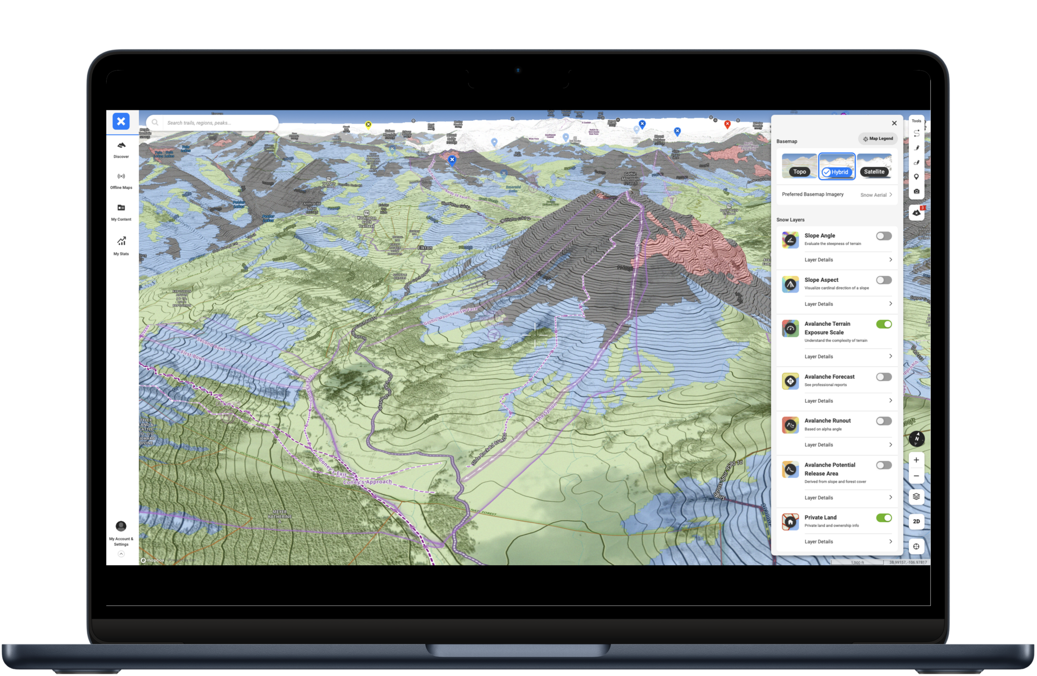
On-X backcountry has a great ATES feature in some areas. You can clearly see when you enter into more challenging and complex terrain.
Most backcountry travelers will be operating on the slope or mountain scale. If you can find an A.T.E.S. breakdown for a specific slope or collection of slopes, you can build a more informed and deliberate travel plan through that terrain. Many modern guidebooks now include A.T.E.S. ratings for each route or area, making this planning process even easier.
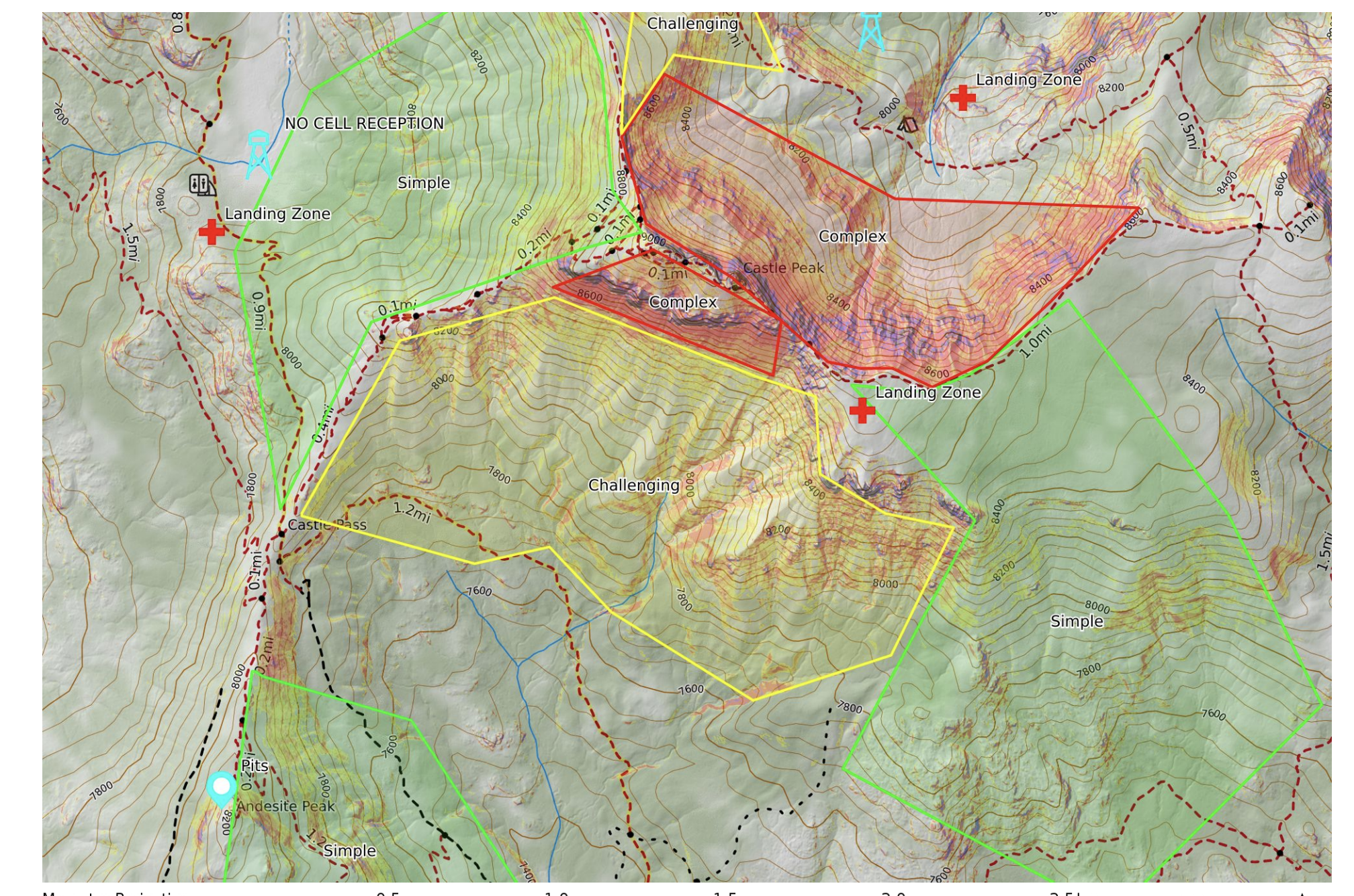
Using Cal-Topo slope angle shading to identify simple, challenging, and complex terrain
So how should you actually travel through avalanche terrain? Ultimately, that decision is entirely up to you and what you want to get out of the day. The A.T.E.S. system is simply another tool in your kit for backcountry travel—although a particularly powerful one. If you’d prefer to avoid avalanche terrain altogether, or stick to areas with very low likelihood of avalanche involvement, you can use your guidebook to choose routes rated as non-avalanche or simple.
Likewise, if your observations and conditions suggest that you can safely push things a bit further, you might consider traveling in challenging or even complex terrain. The system also makes it easy to compare terrain classifications with the day’s avalanche hazard. For example, on a Considerable day with a persistent slab problem, it would be reasonable to cross complex or challenging terrain off the list. On the other hand, on a Low-danger day with easily avoidable avalanche problems, you might finally venture into that complex terrain you’ve been eyeing.
The A.T.E.S. system has proven its value, and public adoption has been overwhelmingly positive. Before long, most popular backcountry trailheads will likely display A.T.E.S. ratings right alongside traditional avalanche information. Adding this tool to your decision-making process will help you build safer, more intentional backcountry travel plans.
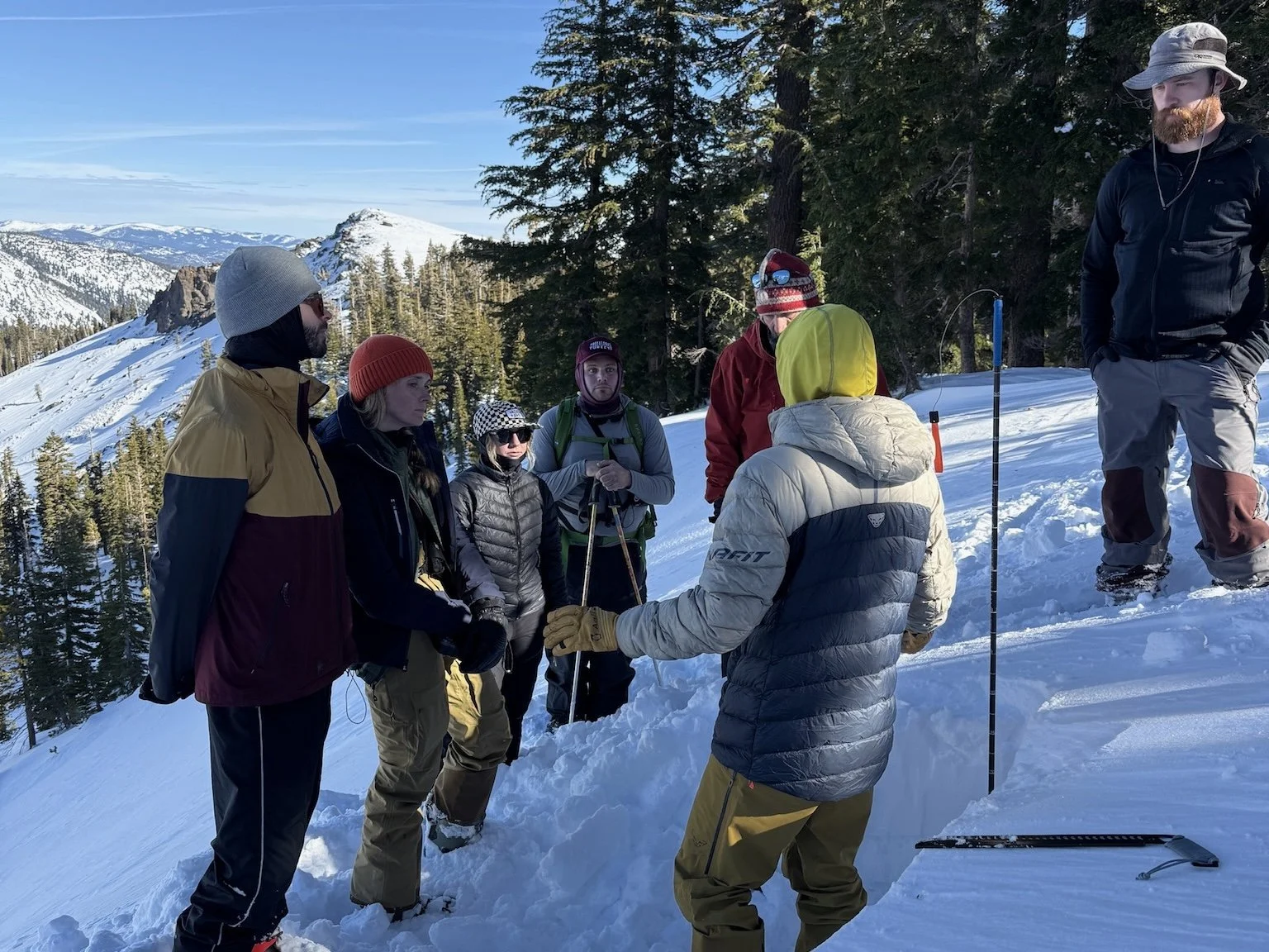
Checking out the snowpack on our AIARE Avalanche Level 1 Course in Lake Tahoe.
Tools like the Avalanche Terrain Exposure Scale are most powerful when you truly understand how to use them—and there’s no better place to develop that skill set than with Valhalla Mountain Guides in Mammoth Lakes and Lake Tahoe.
Valhalla’s avalanche education programs don’t just introduce the A.T.E.S. system—they teach you how to apply it in real terrain, under real conditions. Throughout their AIARE-certified Level 1, Level 2, and rescue courses, instructors incorporate A.T.E.S. into route selection, terrain analysis, and daily decision-making. You’ll gain hands-on experience breaking down terrain features, evaluating exposure, and using A.T.E.S. ratings as an integral part of your tour plan.
Their guides are seasoned professionals who spend countless days in avalanche terrain and understand how to communicate complex ideas in a clear, practical way. By the end of your course, you won’t just know what A.T.E.S. is—you’ll know how to use it to make smarter, safer choices every time you step into the backcountry.